


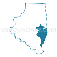
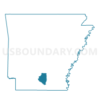
Voting District 4, Calhoun County, Arkansas
About
Outline

Summary
| Unique Area Identifier | 526042 |
| Name | Voting District 4 |
| County | Calhoun County |
| State | Arkansas |
| Area (square miles) | 63.49 |
| Land Area (square miles) | 63.39 |
| Water Area (square miles) | 0.10 |
| % of Land Area | 99.84 |
| % of Water Area | 0.16 |
| Latitude of the Internal Point | 33.47248280 |
| Longtitude of the Internal Point | -92.37362640 |
Maps

Graphs
Select a template below for downloading or customizing gragh for Voting District 4, Calhoun County, Arkansas


Neighbors
Neighoring Voting District (by Name) Neighboring Voting District on the Map
- Banks Voting District, Bradley County, AR
- Jersey Voting District, Bradley County, AR
- Voting District 3, Calhoun County, AR
- Voting District 3C, Calhoun County, AR
- Voting District 5, Calhoun County, AR
Top 10 Neighboring County Subdivision (by Population) Neighboring County Subdivision on the Map
- Township 5, Calhoun County, AR (666)
- Township 3, Calhoun County, AR (610)
- Clay township, Bradley County, AR (568)
- Township 4, Calhoun County, AR (565)
- River township, Bradley County, AR (131)
- Sumpter township, Bradley County, AR (126)
Top 10 Neighboring Place (by Population) Neighboring Place on the Map
Top 10 Neighboring Unified School District (by Population) Neighboring Unified School District on the Map
- Warren School District, AR (8,676)
- Hampton School District, AR (4,062)
- Hermitage School District, AR (2,821)